Open source data management and visualizations for geotemporal data

The geostreaming data framework allows for heterogeneous data to be converted into a flexible schema, provides a web application with data visualizations for end-users to interact with the data and a REST API to create additional web clients and perform computations of the data.

Find Out More

What is Geostreaming Data Framework?


  • Geostreaming data framework is a set of open source software ( NCSA ) tools to help researchers manage and visualize geo temporal data.
  • You can install Geostreaming data framework as needed for your project in the cloud, on your hardware, or you can partner with NCSA for a custom instance.
  • The geostreaming data framework is built to be extensible and support new use cases and domains.
  • Questions? Join the team on the mailing list.

A scalable geotemporal data management and visualization system


GeoStreaming API

A REST API where you can interact with the data. Specific computation for visualizing data is performed in the Geostreaming Api, including computations for bins for the data at different time scales including day, month, season and year. It also calculate trends per parameter for single sensors or a region.
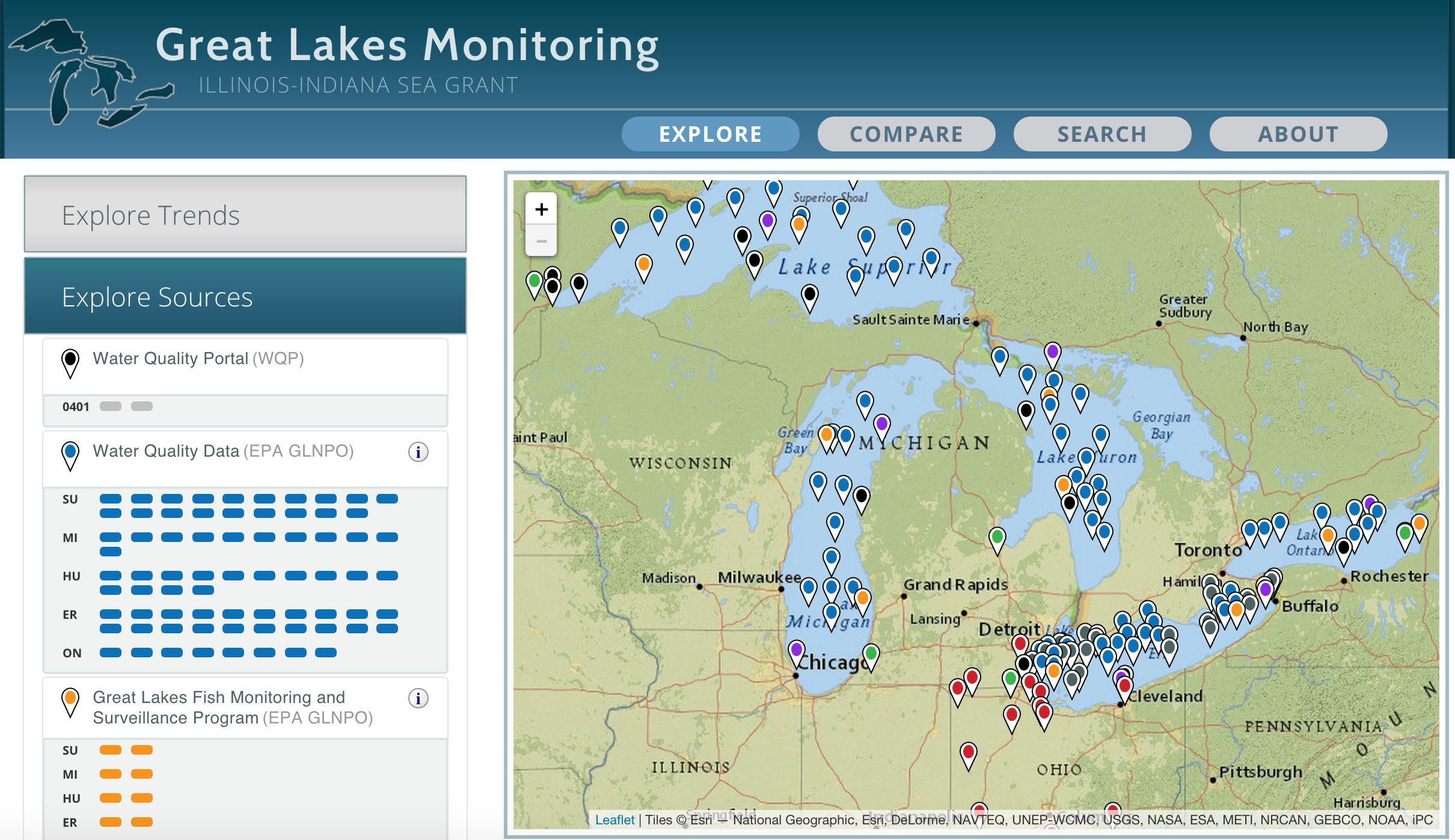
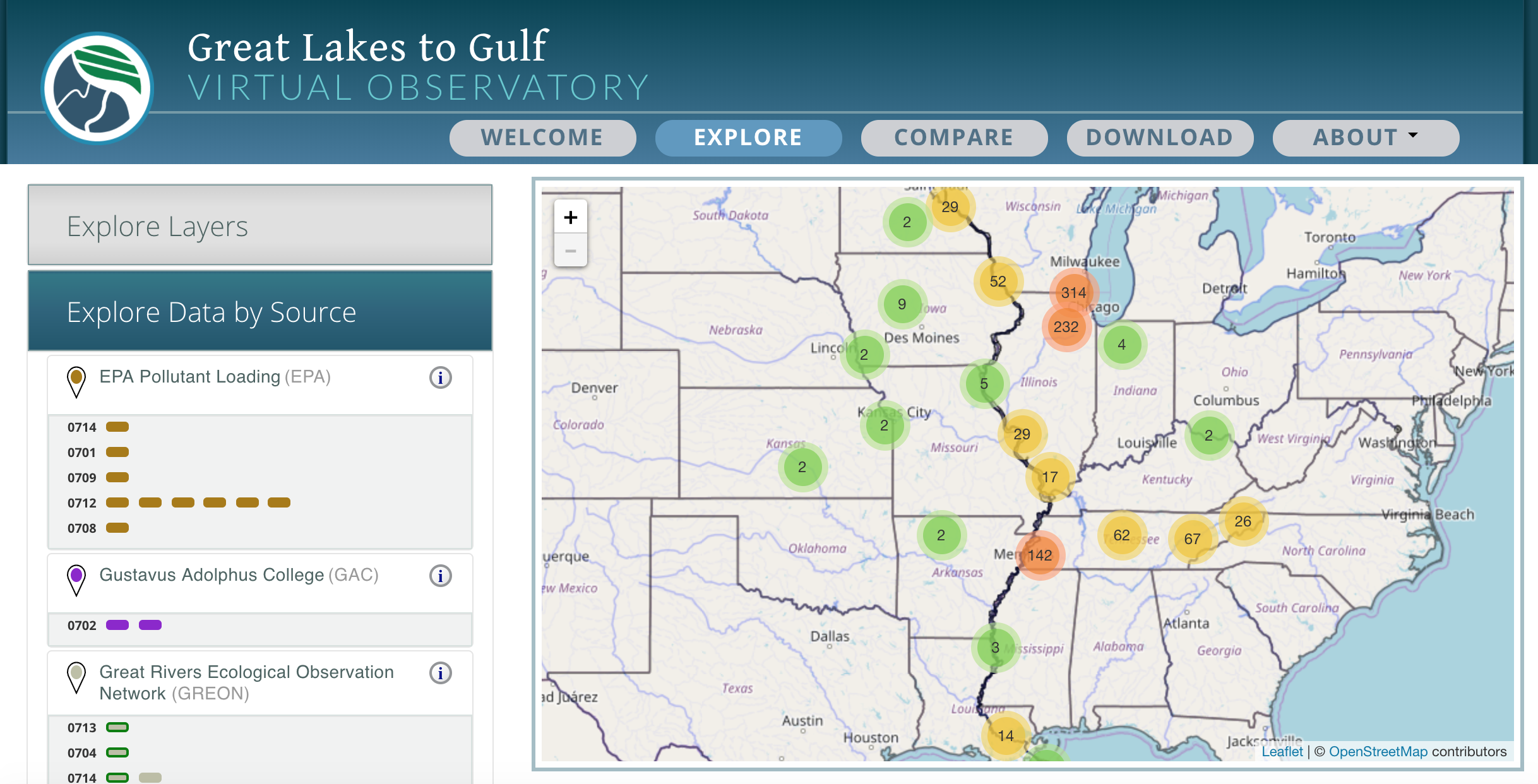
Geodashboard

This is a web-application that allows users to browse and search geo-spatial data in a map. It has visualizations for each location that can be customized to match the community needs. We currently support time-series, box and whiskers, stacked line and stacked bar graphs. Code is developed in React + Redux graphs are created with d3.js and new graphs can be easily added.

Parsers

Data from heterogeneous sources that include images collected from drones or field scanners, sensors in the field, results of labs analyses, remote sensing data, or historical data from heterogeneous sources can be ingested into the geostreaming API with the help of parsers. A Python library PyGeotemporal has been created to facilitate writting new parsers.

Built to be extensible


  • Supports heterogeneous sources of data: embedded in images from drones or field scanners, sensors in the fields, results of lab analyses, remote sensing data, historical data obtained from federal and state sources.
  • Data can be visualized in different graphs. And new graphs can be created using d3.js.
  • Users can browse and search data based on location, source of data, paremeters or time frame.
  • The geostreaming data framework components work great together. But are designed to work on their own if you are only interested in one of them.

Funding Sources


  • Illinois-Indiana Sea Grant – Great Lakes Monitoring
  • NGREC and Walton Foundation - Great Lakes to Gulf Virtual Observatory
  • NSF EAR – Critical Zone Observatory Network for Intensively Managed Landscapes (IML-CZO)
  • ARPA-E - TERRA-REF
  • CDC - Vector Borne Disease

Publications


  • I. Gutierrez-Polo, Y. Zhao, S. Bradley, E. Roeder, M. Pitcel, K. Tepas, P. Collingsworth, L. Marini. "Monitoring Water Quality in the Great Lakes Leveraging Geo-Temporal Cyberinfrastructure," 2017 IEEE 13th International Conference on e-Science (e-Science), Auckland, New Zealand, 2017, pp. 364-373. doi: 10.1109/eScience.2017.50
  • M. Burnette, R. Kooper, J. D. Maloney, G. S. Rohde, J. A. Terstriep, C. Willis, N. Fahlgren, T. Mockler, M. Newcomb, V. Sagan, P. Andrade-Sanchez, N. Shakoor, P. Sidike, R. Ward, and D. LeBauer. 2018. TERRA-REF Data Processing Infrastructure. In Proceedings of the Practice and Experience on Advanced Research Computing (PEARC '18). ACM, New York, NY, USA, Article 27, 7 pages. DOI: https://doi.org/10.1145/3219104.3219152
  • Kooper, R., et al. "Information Architecture Used to Manage Multi-Domain Data Analysis in Intensively Managed Landscape-Critical Zone Observatory." AGU Fall Meeting Abstracts. 2016.

Special thanks


We are very thankful to the following companies for letting us use their wonderful software for free to develop Clowder under an open source license:
  • Atlassian for kindly giving us an open source license to their software development products that make our daily efforts so much easier